


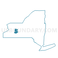
Voting District 070004, Livingston County, New York
About
Outline

Summary
| Unique Area Identifier | 629554 |
| Name | Voting District 070004 |
| County | Livingston County |
| State | New York |
| Area (square miles) | 16.23 |
| Land Area (square miles) | 16.18 |
| Water Area (square miles) | 0.05 |
| % of Land Area | 99.70 |
| % of Water Area | 0.30 |
| Latitude of the Internal Point | 42.89498330 |
| Longtitude of the Internal Point | -77.58050120 |
Maps

Graphs
Select a template below for downloading or customizing gragh for Voting District 070004, Livingston County, New York


Neighbors
Neighoring Voting District (by Name) Neighboring Voting District on the Map
- Voting District 070001, Livingston County, NY
- Voting District 070002, Livingston County, NY
- Voting District 070003, Livingston County, NY
- Voting District 080001, Livingston County, NY
- Voting District 0900001, Monroe County, NY
- Voting District 0900002, Monroe County, NY
- Voting District 0900006, Monroe County, NY
- Voting District 0900008, Monroe County, NY
- Voting District 140003, Ontario County, NY
- Voting District 180002, Ontario County, NY
Top 10 Neighboring County Subdivision (by Population) Neighboring County Subdivision on the Map
- Mendon town, Monroe County, NY (9,152)
- Livonia town, Livingston County, NY (7,809)
- Lima town, Livingston County, NY (4,305)
- Richmond town, Ontario County, NY (3,361)
- West Bloomfield town, Ontario County, NY (2,466)
Top 10 Neighboring Place (by Population) Neighboring Place on the Map
Top 10 Neighboring Unified School District (by Population) Neighboring Unified School District on the Map
- Honeoye Falls-Lima Central School District, NY (13,753)
- Bloomfield Central School District, NY (6,564)
- Honeoye Central School District, NY (5,935)
Top 10 Neighboring State Legislative District Lower Chamber (by Population) Neighboring State Legislative District Lower Chamber on the Map
Top 10 Neighboring State Legislative District Upper Chamber (by Population) Neighboring State Legislative District Upper Chamber on the Map
- State Senate District 55, NY (309,516)
- State Senate District 54, NY (302,881)
- State Senate District 59, NY (297,961)
Top 10 Neighboring 111th Congressional District (by Population) Neighboring 111th Congressional District on the Map
Top 10 Neighboring Census Tract (by Population) Neighboring Census Tract on the Map
- Census Tract 307, Livingston County, NY (7,809)
- Census Tract 505, Ontario County, NY (6,100)
- Census Tract 520, Ontario County, NY (5,025)
- Census Tract 306, Livingston County, NY (4,305)
- Census Tract 124.01, Monroe County, NY (3,017)